“The Crossing”

The Town of Stephenville Crossing is located in Canada on the West coast of the Island of Newfoundland. For those of us who have lived there as well as for those who still live there, the community is affectionately known as “the Crossing” or “the Xing“.

"The Gut"
First Nations
The hills surrounding the bay is home to many wild animals and birds. The most common of these would the woodland caribou, which provided food for the Beothucks, who inhabited Newfoundland long before the first Europeans. There are also many fur bearing animals including beaver, fox, otter and muskrat. The Beothucks lived in the interior of the island in winter and spent their summers on the coast. The “Gut” was very likely a favourite summer location.
The Atlantic Salmon have been coming to the rivers on the west coast of Newfoundland for eons. The attraction was likely the fast moving clean water over sand and gravel bottoms. A perfect environment for salmon eggs to grow and hatch into a new generation of salmon. In the springtime, large numbers of salmon navigate the coastline of the bay to find the river where they were born. Other fish, like cod, herring, halibut and eels were also plentiful.
There is little doubt that the abundance fish was the main reason to visit the “Gut”. All of the salmon that migrated into the rivers at the bottom of the bay had to past through the 500 foot wide waterway called the “Gut”. In other words, the “Gut” was an excellent place to catch salmon. The area in the immediate vicinity of the “Gut” was very sandy with minimal vegetation. Basic forms of vegetation had started and in some cases stunted trees were surviving. The tidal flats inside the “Gut” provided a summer home for large numbers of migratory birds. For the first settlers arriving in Bay St. George, this sandbar may very well have been an attractive location to set up residence.
Well before the arrival of the Europeans, the first nations peoples of mainland North America visited Newfoundland. The Mi’kmaq people crossed the hundred miles of water (the Cabot Strait) between Newfoundland and Nova Scotia to visit Western Newfoundland. According to Dorothy Anger, the area was known to the Mi’kmaq as Nogwa’mkisk, which means “where the sand is blown up by the wind”.1
The Mountagnais crossed the Straits of Bell Isle between Newfoundland and Labrador. Eventually, these peoples would take up permanent residence in areas of the island.
The Geomorphology
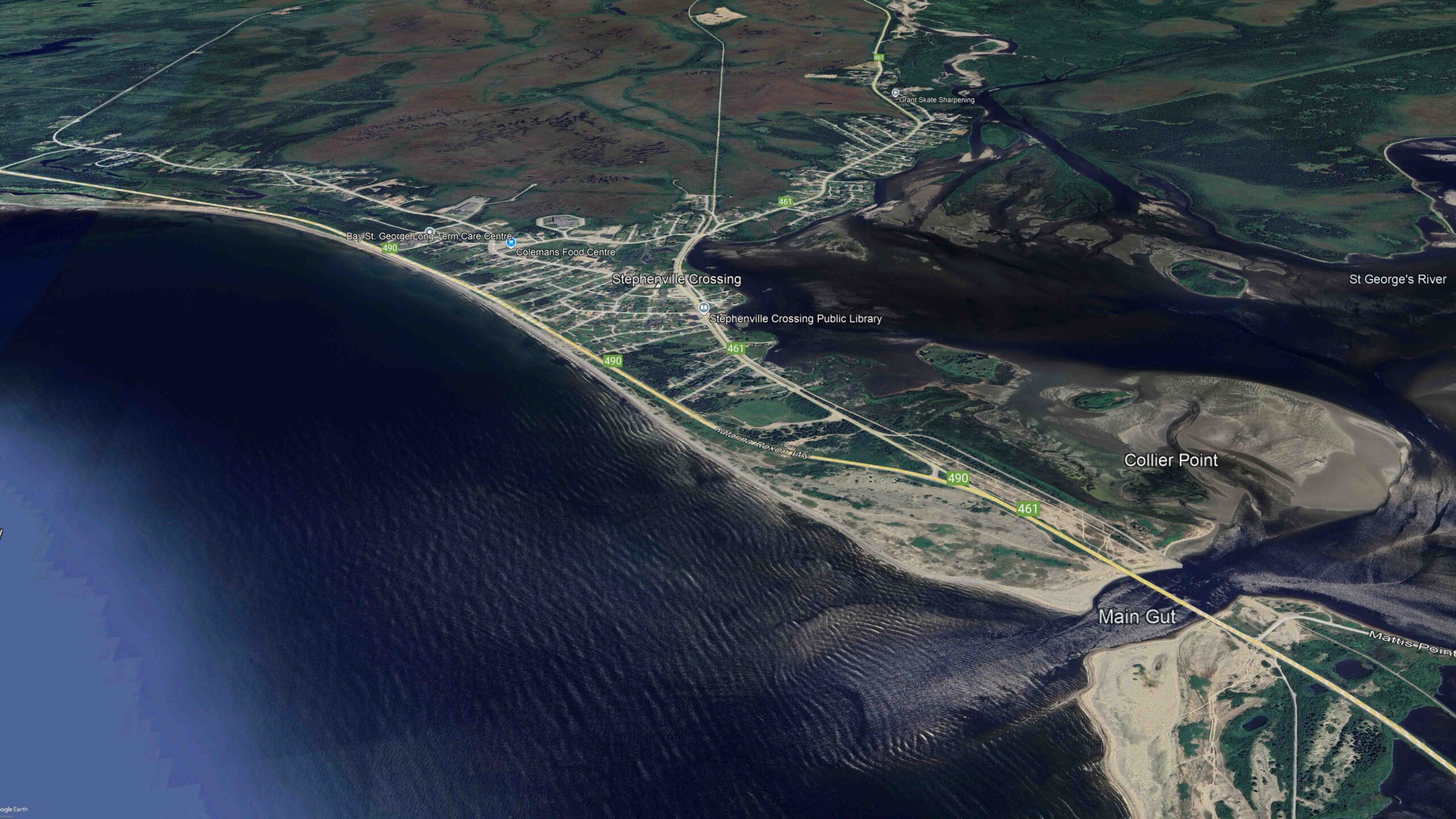
The above Google Earth photo includes the mouth of Harry’s River (near center top) and the sediments deposits in the river delta. Most of Stephenville Crossing is is located on a sand bar at the mouth of Harry’s River.
The sand bars near the mouth of Harry’s River are more than 3 kilometers long and up to 2 kilometers wide in places. The land is flat and most of it is less than 10 meters above sea level. In the early historical records, the area was sometimes referred to as “The Prairie”.
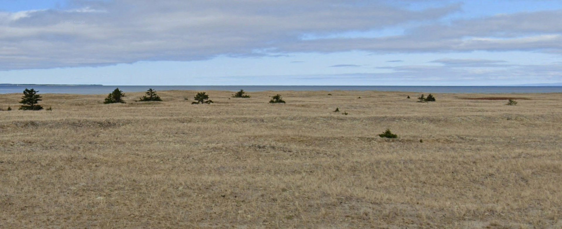
One can see why the area might sometimes be referred to as “The Prairie”.
A barachois is a type of coastal lagoon partially or totally separated from the ocean by a sand bar. It is a term that is commonly used in Atlantic Canada.
Interestingly, the body of water captured by the sediments of Harry’s River includes a body of water that is 11 kilometers long and 2 kilometers wide. Nevertheless, the sand bar created by the river and the currents in the bay, partially separated the ocean from this body of water. This body of water is locally known as “the bay”. Normally, a lagoon is a “shallow body of water”. Most of “the bay” does meet the shallow water criteria. It is more like a lake, not unlike the Bras d’Or Lakes in Nova Scotia.
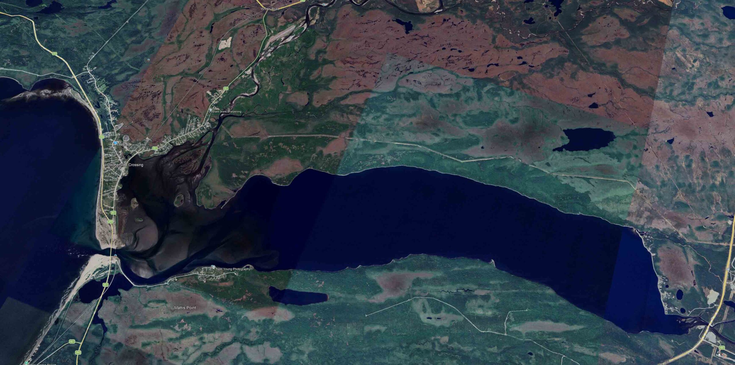
The combined discharge of three major rivers finds it’s way into Bay St. George through an opening in the sandbar . This opening, located near the south side of the bay, is known as “the Gut”. When you consider the natural evolution of the sand bars, there may have been a time when there was more that one opening.
“Gut” is a term used by geographers and sailors when referring to a “narrow channel or passage” normally found in coastal areas and quite often near the mouth of rivers.
During the rising tide, salt water from Bay St. George flows through “the Gut” and into “the Bay”. “The Gut” is about 500 feet wide and when the tide goes out, the flow through the opening includes the discharge of Harry’s River, Bottom Brook, Southwest Brook, as well as several other smaller streams that flow into “the Bay”. On the rising tide, the salt waters of the bay flow into “the Bay”. The reversing flow can, at times, exceed 6 knots. Inside “the gut”, the fresh water from the rivers mixes with the salt water of Bay St. George, resulting in a “brackish” water, meaning that the level of salinity of the water inside “the Gut” is lower than that of the ocean.
It is interesting that the Gut was often referred to as the “Main Gut”, which implies that there were other openings in the sandbar. A look at that scenario can be found at; https://gallivanting.ca/some-oral-history/
The History
What was happening in other parts of the world played a significant role in the history of Bay St. George. From the early 15th century, Europeans fished the waters of Newfoundland. These fishing vessels sailed from France, Spain and Portugal in the spring and returned to Europe in the fall with their catch.2
The wars between England and France, sometimes called the colonial wars, were fought primarily over the colonies in North America.
The War of Spanish Succession (1702-1713) ended with the “Treaty of Utrecht”. By this treaty, France ceded to Great Britain it’s claims to Newfoundland and Acadia (parts of present day Nova Scotia and New Brunswick). France retained Isle St. Jean (Prince Edward Island) and Isle Royale (Cape Breton Island). An important part of this treaty is referred to as the “French Treaty Shore”, which gave the French the right to fish the coast of Newfoundland between Cape Bonavista and Point Riche.

The Treaty of Utrecht provided that the French could fish in season on the Newfoundland coast between Cape Bonavista and Point Riche.
The War of Austrian Succession (1740-1748) was fought for the most part in Europe. The French fortress at Louisbourg, on Isle Royale, was captured by the British in 1745, but was returned to the French at the end of the war. It was the end of this war that marked the beginning of the struggle between England and France for control of the colonies in North America.
The Seven Years’ War (1754-1763) ended French dominance in the new world. France gets the islands of St. Pierre and Miquelon off the coast of Newfoundland. During this war, more than 10,000 Acadians were expelled by the British. In 1764, the Acadians were officially given permission to return to Nova Scotia.

The American Revolutionary War (1775-1783) was also known as the American War of Independence. In 1783, England and France signed the Treaty of Versailles. The Islands of St. Pierre and Miquelon remain with France. Significant to Newfoundland were the changes in the “French Shore”. The boundaries of the “French Shore” were changed to the coastline between Cape St. John to Cape Ray. France would sent fishing fleets to the “French Shore” until 1904. It is important to note that Bay St. George is now included in the new “French Shore”.
The granting of fishing rights on the west coast of the island to France would have some interesting consequences.
In 1783, there was very little documentation of settlement in Bay St. George, although it is believed that there were some “livyers” in the bay at that time.
As a result, the French fishing fleet fished the west coast during most summers. The French fishing fleet, operating out of St. Pierre and Miquelon, would fish the French shore from seasonal fishing station on the west coast.
The fishing stations in or near Bay St. George included Codroy Island near Cape Anguille and Île Rouge aka Red Island on the Port Au Port Peninsular near Cape St. George.


For most of the 19th century, settlers on the “French Shore” lived in a constant state of uncertainty. They felt threatened by both the French and the English. The sight of navel vessels in the bay, French or English, caused much fear in the community. The French Fishery on the west coast of Newfoundland ended in 1904.3
The First Livyers
What follows is an excerp from the Reverend Michael Brosman’s book “The Pioneer history of St. George’s Diocese”.
The Reverend Michael Brosman wrote;
“About the first part or middle of the last century (i.e., 18th century) one Henri L’Official, a Frenchman, arrived in Quebec. After a short sojourn in that Province he became acquainted with a young French-Canadian, whose Christian name was Nannette, this young lady he subsequently married and shortly after, for some reason or other which I cannot understand, sailed down the St. Lawrence in a small craft of his own, taking with him his wife. Making for the Straits of Belle Isle he met with adverse weather and was wrecked and driven ashore some miles north of Bay St. George. At this point he managed to spend the winter somehow and the summer following made his way to Sandy Point, the chief settlement of this same Bay. He settled here among a few Jersey families that were already in possession of the place. Of his union with Nannette there was two daughters and one son. The career of the latter is lost, but one of the daughters it is known to have married in Cape Breton, the other formed an alliance with a Frenchman born on the passage from France, this man’s name was Benoit. From this union sprang a long lineage. The name Benoit is common in all parts of Bay St. George: in most cases in the original French spelling and in many instances in the English translation or adaptation Bennett. By intermarriage with their French neighbours or with compatriots of France or Canada their numbers rapidly increased.”4
According to the Roman Catholic church records of St. Pierre, the marriage of Jean Camus and Marie L’Official was revalidated in 1791. The records also indicate that the couple were first married at Bay St. George on July 20, 1790.
Included in the church records of the “Paroisse de Notre Dame de Quebec”, is the revalidation of the marriage of “Jean Rene Camus, native fisherman of St. Pierre, …. and Marie L’Official native of Bay St. George, Island of Newfoundland”. The entry is dated September 23, 1799. This documentation also states that Marie L’Official is the daughter of Henri L’Official and Elizabeth Shegone and that the first celebration of their marriage actually took place at Bay St. George on September 23rd, 1792. Accompanying Jean Rene and Marie were their children; Jean, Jeanne and Elizabeth. They were also accompanied by George Camus, Jean Rene’s brother, Marie’s sister Anne and her husband Francois Benoit. It would appear that Henri L’Official was a very real person and that indeed he lived at Bay St. George in the the last half of the 18th century.
Although it is safe to say that the L’Official family, the Benoit family and a few Jersey families were resident at Bay St. George before 1792, it is not clear exactly where Henri L’official lived in Bay St. George. Some have suggested that he lived at Main Gut or Main River. One of the more interesting place names in Bay St. George is Fishells. According to David E. Scott, “The name origin is believed to be a french surname“5. Fishell’s sounds a lot like L’Official’s.
What is most interesting about the L’Official family is that they travelled quite extensively for the period. First, Henri L’Official immigrates from France to Quebec, where he meets a young Quebec girl and gets married and has two daughters, Anne and Marie. Sometime in the 1780s, for some unknown reason, Henri L’Official and his wife, with their young daughters, head down the St. Lawrence river in a small boat. They end up living in Bay St. George. Then in 1791, they travel, by boat, to St. Pierre off the south coast of Newfoundland, while the church records at Quebec, record a visit to that City in 1799. While one could rationalize a trip to St. Pierre to see a priest, the purpose of a trip to Quebec City was more than likely to visit family. On the trip to Quebec, Henri L’Official and his wife were accompanied by; their daughter Anne and her husband Francois Benoit, their daughter Marie and her husband Jean Rene Camus and Jean Rene’s brother George Camus. Also on the trip were Jean, Jeanne and Elizabeth, the daughters of Jean Rene Camus and Marie L’Official.
It is fair to say that for a family living in Bay St. George in the 1790s, such an undertaking was no easy feat.
This information raises a number of questions, with respect to the wife/wives of Henri L’Official. Is Elizabeth Shegone and Nannette the same person or might Elizabeth be another wife of Henri L’Official? According to Brosman, “Of this union with Nannette, there was two daughters and one son”. The church records states that Marie L’Official is the daughter Henri L’Official and Elizabeth Shegone. Could Marie be Henri’s third daughter?
In 1808, when the H. M. sloop “Avenger” visited Western Newfoundland, St. George’s Bay had 102 inhabitants.
It is not known exactly when the first Europeans settled in Bay St. George, but most researchers agree that it was during the latter part of the eighteenth century.
The following is quoted from the Red Island Heritage Website.
“Charles de la Morandiere, working with French naval documents, informs us that in 1821, there were thirteen families at St. George’s harbour and five at ‘Grand Barachois’ (likely in the area of Main Gut). The officer’s report consulted by de la Morandiere tells us further that some forty years earlier, in about 1780, only two families were in the area, one at each location.”3
Based on the assumption that the “Grand Barachois” is a reference to the area at the “Main Gut”. Although St. Georges Harbour is well defined geographically, there is some doubt as to the exact location of the “Grand Barachois”. According to de la Monrandiere, there was one family living at the “Grand Barachois” in 1780, with four families joining them by 1821.
In 1820, the french explorer, navigator and cartographer, Lieutenant Hippolyte Le Saulnier de Vauhello visited Bay St. George. Vauhello carried out soundings of the bay and produced a navigational chart of the bay, which was published in 1822.
Lieut. Vauhello Bay St. George 1819 survey, published 1822. The Main Gut is on the right side and labelled “Rivière Saint George”.

Source; Memorial University of Newfoundland – Digital Archives Initiative
Interestingly, Vauhello included buildings/houses on his chart. A close examination of the chart shows 19 buildings/houses at Pointe de Sable (Sandy Point).

The sand and gravel deposits in the area of the gut are effected by the tidal currents at the gut as well as the currents in the outer bay.
 – HD")
Based on the 1819 Bay St. George survey by Lieut. Vauhello (published 1822), the 2 houses on the north side of Rivière Saint Georges (the Gut) are “two families of Indians who are involved in fishing salmon”.
In the summer of 1835, Archdeacon Edward Wix while visiting Bay St. George, made an interesting visit to Main Gut. According to Wix, three or four families resided at this location.

On Monday, July 6, 1835, Reverent Wix took part in some nighttime fishing. More than 1000 sea trout were speared from 5 canoes in about 2 hours.
The following is an excerpt from his journal for July 6, 1835;
“Monday 6, Went, this week, to visit the salmon fisheries, which are upon the main gut. Three or four families reside there. One night; as some of the people and an Indian boy were going out just at the rise of high tide, five canoes in all, to spear trout and eels, I joined them in the excursion. It employed us till an hour or two after midnight. The scene was an animating one. A brilliant moon hung over the hills, which were finely wooded, to the very cliffs and sand at the edge of the water. Bunches of birch bark were packed together, a dozen in each packet; these were stuck one at a time, as required, into a stick which was cleft at the top to let in this rude flambeau, to which a light was applied. The stick with the ignited birch bark was then put upright at the bow of the canoe; there, also, the man stood up, most insecurely balanced, as would seem, with his nighok, or eel-spear, a pole cleft at the bottom with a spike inserted. This, on his striking a fish of any size, would open and admit it till the spike perforated it, and then closing upon it, would press it and prevent its escape. The sandy or stony bottom of the river in the shallows,–for in deeper water this sport cannot be pursued, was seen as clearly as in the day, and every fish in it. The fish seemed at least bewildered, if not attracted by the light; and the quickness of eye, and adroitness of the man who used the nighok, impelling, as he did, the canoe with the thick end, and every now and then reversing it to strike, were surprising. He struck successfully at eight out of ten of each of the fish at which he aimed, and shook them off into the boat with a sudden turn of his arm, which left him at liberty to strike at two fish within a second or two. He kept his balance, also, with great niceness, when he seemed to have poised himself so far over the side of the light canoe, that he must, it seemed to me, have gone over-board, or capsized our crank bark. The light of the flambeau in the other canoes, as they came round the projecting points of leafy green; and the shade, as we again lost view of them behind the trees or rocks in the distance, was most imposing. Four hundred trout were thus speared in the canoe in which I was; some of them, were of such a size, that they would have been taken, as they frequently are, in the salmon nets. In the five canoes, above 1000 were taken in little more than two hours. I had the curiosity to weigh six of them, which together weighed twenty-two pounds, and had a barrel of this night’s catch salted that I might take them with me to St. John’s.”11
The 1839-40 Census of Bay St. George
In 1839, British surveyor J. B. Jukes visited the western shore of Newfoundland.6 Juke’s account of his visit to Bay St. George includes the most comprehensive census of the area to date and included the following comments;
“The population seemed to be about half French, the rest English, Jerseyman, and a few Indians. There might be perhaps 500 or 600 people at this time (August 25, 1839), but these are mostly transitory inhabitants. The French all leave in November and return in May, and most of the others retire either to more distant settlements or to houses in the woods on the opposite shore during the winter.”6
The community referred to in his report is Sandy Point, with the opposite shore being St. Georges. The “French” include 24 families and are listed as natives of Cape Breton.
In 1839-40, the Joseph Jukes list included 4 families living at the “Gout” or “Le Belier”. It is assumed that this place is the “Gut”, later would be referred to as “Main Gut” and “Main River”. It should be noted that “Gout” does translate to “Gut”, while “Le Belier” is a noun meaning; “Ram; (battering) ram, Aries,”. The conclusion that the “Gut” is the same place as the “Main Gut” is based on the names of residents, which is consistent with later records.
From Juke’s List of Inhabitants of the Western Shore, 1839-1840;5
Name of Settlement – Gout/Le Belier
Resident Age Time here (Years?) Native Place
F. Bennett 80 50 Canada
J. Lucaw 40 15 France
Jn. Paley 45 15 St. Pierre
J. Young 38 8 St. Pierre
All are listed as English subjects from their birth, but of French decent.
All are listed are involved with the salmon and herring fishery.
Number in family listed as 30 or 40 is likely a reference to the total population of Gout/Le Belier.
Francois Benoit and Anne L'Official
Interestingly, F. Bennett is 80 years old and has been living at this location for 50 years. Could this F. Bennett be the same Francois Benoit that was resident in the bay in 1792? Gerald Thomas concludes that the F. Bennett, resident at the “Gut” in 1839-40 is the same Francois Benoit that married Anne L’Official at Sandy Point in 1790.6
It is important to note that there were two other Bennett families living at Sandy Point in 1839-40. The descendants of the Bennett/Benoit families still live at Stephenville Crossing.
F. Bennett is very likely Francois Benoit, husband of Anne L’Official, daughter of Henri L’Official and Elizabeth “Nanette” Chego/Chegeu/Shegone. In 1839-40, Francois Benoit indicated that he had been resident at the “Gut” for 50 years (thus arriving about 1790), which would suggest that he was thirty years old when he relocated to this place. It is also possible that Anne’s parents, Henri L’Official and family also lived at the “Gut” at some point.
Jean Benoit and Judith Lejeune
It is very likely that Jean Benoit, the son of Francois Benoit was residing with his parents at the time of this census. Jean was born about 1804 and was married to Judith LeJeune. It is reasonable to assume that Judith LeJeune is a decendaant of Germain LeJeune (1702-aft 1771).
In June, 1859, when questioned by the Fisheries Commission, Jean Benoit replies;
“I am 55 years old …… My father is a Frenchman and my mother was from Quebec”.
The suggestion is that Jean Benoit’s father, Francois Benoit came from France, likely via Saint Pierre.
It also suggests that Jean Benoit’s mother, Anne L’Official, daughter of Henri L’Official and Nanette came from Quebec.
In his book, “The Pioneer History of St. Georges Diocese”, the Reverend Michael Brosman states;
“Of his union with Nannette there was two daughters and one son.”
When Jean Benoit was questioned by the Fisheries Commission about his place of residence, he replied;
“at the Main River, by the sea……. My father built the house. I was at the end of the bay. There was no fish.”
Following the arrival of Father Belanger at Sandy Point in September of 1850, many families revalidated or “churched” their unions and baptised their children. In May of 1851 , a number of families gather for just this purpose.
On May 21, 1851, Jean Benoit and Judith LeJeune revalidated their marriage, while their son Jean Benoit and Helene Benoit were married the following day on May 22, 1851.
Jean Marie Lucas and Henrietta LeJeune
According the records of the St. George’s Mission, a Jean Marie Lucas died on December 7, 1857. It was recorded that Jean Marie Lucas was about 60 years old and was born in France. There is little doubt that this Jean Marie Lucas is the same person listed in Juke’s list as J. Lucaw.
Many Descendants of Jean Marie Lucas and Henrietta LeJeune still reside at Stephenville Crossing. It is reasonable to assume that Henriette LeJeune came to Bay St. George from Cape Breton and is a descendant of Germain LeJeune (1702-aft 1771).
It is also very likely that Henrietta LeJeune and Judith LeJeune were related.
J. Lucaw and J. Paley arrived at the “Gut” about 1825, while J. Young arrived about 1830, yet de la Morandiere suggests that there were five families living at this location in 1821. We can only assume that someone relocated or passed on.
Jean Pillet and Marie LeJeune
J. Paley indicated that he is 45 years old and that his native place is St. Pierre. We can assume that he has lived at this place for 15 years, arriving about 1824. According to the records of the Church of the Immaculate Conception at Sandy Point, a Marie LeJeune (b. 1815) died on April 11, 1853. Her husband is listed as Jean Pillet. “Pillet”, pronounced with a French accent, sounds very much like “Paley”. The parents of Marie LeJeune are listed as Alexander “Alexis” LeJeune and Anne Eleanor Querk. Jean Pillet died on October 1, 1863 and the record lists his birthplace as France. His wife is listed as Marie LeJeune. It is reasonable to assume that J. Paley is Jean Pillet.
Could it be that Marie LeJeune, Henriette LeJeune and Judith LeJeune are related to each other? My guess is yes, but how?
J. Young
J. Young indicated that he is 38 years old, a native of St. Pierre and has lived at this location for the past 8 years. The records suggest that J. Young was born about 1800 and arrived at this location about 1830.
Some researchers have speculated that this J. Young was James Young (1803-aft1871) of Petit Bras d’Or on Cape Breton Island. At this point, it is important to note that, this same list of inhabitants (1839-40) includes two James Youngs, both living at Sandy Point. Both James Youngs indicate their native place as Cape Breton. It is more than likely that the two James Youngs were father and son. The older James Young being Jacques Christophe LeJeune (1779-1872), who married Catherine Jesseau and moved to Bay St. George in 1826 (here 12 years). James and Catherine had a son named James born about 1803 who also moved to Bay St. George.
The fact that the J. Young living at “Le Belier” or the “Gout” indicated his native place as St. Pierre may give some clue as to his identity. The List of Inhabitants in District of Little Bras d’Or for 1818 included a Joseph Young who was born on the island of Miquelon in 1763. Also listed are Joseph’s two sons John and Flehaven. Joseph and both his sons list their country as Newfoundland which is a reference to the Island of Miquelon. John Young was born in 1797.
In 1851, when John’s son, George Young married Susanne Webb at the St. George’s mission, the record included “……..George Young, son of John Young and of Catherine Bouthillier of this mission“. To date, this is the only suggestion that John Young and his wife Catherine Boutillier may have lived in Bay St. George, but it is valid documentation. If John and Catherine lived in Bay St. George, it would be no surprise if he listed his native place as St. Pierre.
There were six other Young families living in Bay St. George at the time of Juke’s visit. They were all resident at Sandy Point and listed their native place as Cape Breton. It is most likely that these Young families were part of the LeJeune families from the Petit Bras d’Or area of Cape Breton.
Did John Young and his brother Flehaven Young relocate to the west coast of Newfoundland in the 1820s?
Before the arrival of Father Belanger in 1850, there is very little documentation of the people who lived in Bay St. george. Nonetheless, Forrest’s List of 1858 included a J. Young(Flewen). Also living in Bay St. George at this time was Andre “Flavin” LeJeune. The family lived at Middle Brook, which at the time was known as “Flavin’s Gulch“.
It is interesting to note that of the four families living at the “Gut” in 1839-40, three of them included a female member of the LeJeune family. There is little doubt that the pioneer families of today’s Stephenville Crossing include the Benoit, Lucas, Pillet and LeJeune families.
The 1840s
The 1840s brought significant numbers of settlers to Bay St. George, with many of them coming from the Cape Breton area of Nova Scotia. Also contributing to the population were the many “deserters” from the French fishing fleet, which fished the “French Shore” during the summer months. These fishermen from France settled primarily near Cape St. George, but mixed quite comfortably with Acadians from Cape Breton.
Sometime, during this period, Andre Alexander arrived at the Main Gut. Andre was born in Cape Breton and was married to Sophie LeJeune. Although, it is difficult to ascertain the the date of their union, it was likely before the census of 1839-40 and consequently before their arrival at Main Gut. The LeJeune connection likely played a part in their decision to reside at Main Gut.
Andre Alexander died at the age of 45 years on 29 November 1857. Andre’s wife, Sophie LeJeune died at Mattis Point on 30 November 1915 at the age of 105 years. Interestingly, Andre’s father, Jean Marie Alexander of Petit bra d’Or was also married to a LeJeune girl (Julie Marie).
It was during this period that the March family, also with a Petit bras d’Or connection, arrived in Bay St. George. The Marche family also had many connections with the LeJeune/Young family of Petit bras d’Or. The “1818 List of Inhabitants of Petit bras d’Or” includes a Jean Joseph Marsh. Jean was born in France and came to Cape Breton via St. Pierre and Miquelon. Several of Jean’s sons and daughters would find their way to Bay St. George.
Jean Joseph Marche had a son John Joseph Marche who married a sister of Catherine Boutilier, the wife of Jean LeJeune, who could very well have been the J. Young living at the Gut in 1839.
Francois Marche, also a son of Jean Joseph, married Charlotte LeJeune, while another son John Marche married a Marie Martha LeJeune and lived on Isle Rouge for a while. A daughter, Ursule married Benjamin LeJeune.
The 1850s
On the 7th of September, 1850, the Rev. Father Alexis Belanger, the first resident priest assigned to the west coast of Newfoundland, arrived at Sandy Point. By this time, Sandy Point was the most significant community on the West Coast of Newfoundland. The need for a priest in the bay becomes evident when you review the records of the Church of the Immaculate Conception which were maintained by Father Belanger. The first marriage recorded on September 20th, 1850 was that of the daughter of Jean Alexander and Julie LeJeune, Sophie Alexander, who married Eustache Batari of Grandville, France. Many couples who had been married by a lay person in the community, were re-validating their unions.
During the 1850’s, the following families lived in the vicinity of Main Gut;
February 21st, 1851, – John Ryan married Marie LeJeune. Only 6 years later, John Ryan passed, on February 10th, 1857.
May 21st, 1851, – Jean Benoit married Judith LeJeune, while on May 22nd, the next day their son, their son, Jean Benoit married Helene Benoit.
April 11th, 1853, – Marie LeJeune, the wife of Jean Pillet passed.
November 29th, 1857, – Andre Alexander, the husband of Sophie LeJeune passed.
December 7th, 1857, – Jean Lucas, the husband of Henrietta LeJeune passed.
Forrest's List - 1858
The 1850’s were not the easiest of times for the residents of Bay St. George. In October of1858, Henry H. Forrest, a Sandy Point merchant, made an appeal to the government of Newfoundland for relief for the distressed people of the St. George’s area. At the time, the Treaty Shore was patrolled by both English and French warships, both competing for control over the territory. The French had recently proclaimed their right to the fishery on the coast, which threatened the livelihood of all residents. Forrest’s list of destitute families8 included four hundred and forty four persons. Included in the list were the residents at Main Gut. Based on the Juke’s List of Inhabitants of the Western Shore6, 1839-1840, I believe that some of these families can be identified.
John Lucas: Jean Marie Lucas passed on December 7, 1857. This household is assumed to be that of Jean Marie Lucas and Henriette LeJeune as listed in the 1838-39 Census. There are now 11 persons in the household.
Jean Pillet: Jean Pillet and Marie LeJeune was listed in the 1838-39 census and now have 6 persons in their household. Marie LeJeune passed on April 11, 1853.
John Benoit: Jean Benoit Jr. was the son of Jean Benoit and Judith LeJeune and was married to Helene Benoit. They have 5 persons in their household.
Oliver Benoit: Oliver was very likely the son of Jean Benoit and Judith LeJeune. They would have 4 persons living in their household.
George Benoit: George was the oldest son of Francois Benoit and was married to Charlotte Alexander, the daughter of Jean Marie Alexander Sr. of Cape Breton.
John M. Alexandre: Jean Marie Alexander Jr. and Julie Marie LeJeune have 6 persons in their household.
The 1860s, 1870s and 1880s
Documentation from this period is limited with the exception of the Immaculate Conception RC church records at Sandy Point10 and the Bay St. George District Census Records9.
Lovell's Directory - 1871
The “Gut”, “Main Gut” or “Main River” are not listed in the Lovell’s Directory for 1871. It would appear that some of the residents at this location show up in the listing for other communities in the bay. Included in the listing for Indian Head are an Alexander Luckoo and a John Luckoo, were very likely Alexander Lucas and John Lucas, miss-spelled. In the French pronunciation of Lucas, the “s” is silent. The list also includes a John Alexander and several fisherman with the name Benoit.
During the second half of the nineteenth century, many new family names showed up in the area known today as Stephenville Crossing. The following events are documented in the Sandy Point Immaculate Conception Roman Catholic Church Records;
On September 7, 1879; Andrew Hawkins married Eugenie Lucas, the daughter of Jean Marie Lucas Jr. and Veneranda Cormier of Main River.
Andrew and Eugenie take up residence at Main River.
On January 7, 1880; Charles Duval, the son of Charles Duvall Sr. and Francoise Benoit married Elizabeth Lucas, the daughter of Jean Marie Lucas Jr. and Veneranda Cormier of Main River.
Charles and Francoise take up residence at Main River.
The 1890s
Although, telegraph services in Newfoundland began on the east side of Newfoundland in the early 1850s, the lines were not completed into the Bay St. George area until 1876. By this time surveys for a railway across the Island of Newfoundland were well underway. Early in the process, St. Georges Harbour was being proposed as the western terminus of the railway. The fact that Bay St. George was located on the French Shore caused some concern for the British Government and eventually, these plans would change and Port Aux Basques would become the western terminus of the Newfoundland Railway. St. Georges would become a important stop. It is important to note that at this point in Newfoundland’s history, St. George’s harbour was the most significant community on the island’s West Coast.
McAlpine's Directory - 1894-95
The 1890s would bring unprecedented change the people living at the “Main River”. In 1894-95, McAlpine listed 38 fisherman living at Main River. By this time, railway surveyors had already been working in the area. It is very likely that most, if not all the residents were very much aware that the railway was coming.
"The Coming of the Railway"
For most of the 18th century, settlers on the “French Shore” lived in a constant state of uncertainty. In 1783, the Treaty of Versailles gave the French the right to fish the French Shore, including the right to use shore facilities. At this point in the history of Newfoundland, the French Shore had a somewhat precarious existance.
By 1800, Bay St. George became the hub of activity on the west coast of Newfoundland. The most significant community being Sandy Point.
In 1881, construction began on the Newfoundland Railway. At the time, the plan was to build a narrow gauge railway from St. John’s to Halls Bay.
By 1892, the Newfoundland government changed the terminus of the railway to the town of St. George’s in Bay St. George, which was later revised to Port Aux Basques on the southwest corner of the island of Newfoundland.
In May of 1893, the Reid Newfoundland Company signed a contract to build and equip the section of railway between the Exploits River and Port Aux Basques.
In 1896, the railway came to “Main River” in Bay St. George. At this point in time, the area was home to about 40 families, with a population of about 100 people.

The Main River, which flows into Bay St. George at the “Main Gut”includes the discharge of three significant rivers, namely Harry’s River, Bottom Brook and Southwest Brook. The flow at the gut is also reversed by the tides, where currents can at times exceed 6 kts.
In addition to laying tracks, the “Gut” would need to be bridged.
Many of the residents of the area were hired by the Reid Company. For most, if not all, this was their first job. Up until now, the people living on this shore were fisherman, who depended on their catch and wild game to feed their their families.
The first official train to cross the island of Newfoundland arrived in Port-aux-Basques on June 30, 1898. It is reasonable to assume that the first bridge at the gut was completed sometime before June, 1898.
The first bridge at the “Gut” had a lift or swing facilty to allow the passage of boats into and out of the inner bay. However, since the lift facility was seldom used, the lift service was discontinued following ice damage in 1901.


By the end of the nineteenth century and after the completion of the railway, the residents of the Main River area were no longer confined to living in the immediate area of the “Gut”.
McAlpine’s Directory for 1898 included a Victor Young living in Seal Cove and 38 families living at Main River. It is very likely the community of Main River included Mattis Point.
McAlpine’s directory for 1904 included; 4 fisherman living at Seal Cove, the Prairie listed 2 Benoit families, 1 Hawkins family and 4 Lucas families. Main River has a listing of 24 families. It is most likely that a large number of the families listed for Main River actually were living at various locations, including Mattis Point. The new railway station was built in the vicinity of the Prairie.
Prior to the coming of the railway, census information included the following communities:
Main Gut – It is reasonable to assume that this refers to the area near the narrow opening in the barachois on the South side of the bay.
The Prairie – This refers to the area near where the first railway station was built.
Seal Cove – A cove on the North side of the bay.
Mattis Point or Matt’s Point – A community on the South side of the bay approximately 2 kilometers inside the Main Gut.
Main River – It would appear that up until the coming of the railway, Main River included Mattis Point, the Main Gut and sometimes the Prairie. There did not appear to be a standard approach.
The 1911 census was the first census to shed some light on where people actually lived. It was the first detailed census of the area and included the following place names;
Seal Cove – 10 families (31 people
Harry’s Brook – 5 families (38 people)
Matt’s Point – 19 families (93 people)
Main River – 4 families (17 people)
Stephenville Crossing (The Railway Station) – 26 families (162 people)

1904 McAlpines List
Main River – 24 families
The Prairie – 7 families
Seal Cove – 5 families
1911 Census
Main River – 4 families
Seal Cove – 5 families
The Prairie – 7 families
Harry’s Brook – 5 families
Matt’s Point – 19 families
Stephenville Crossing – 26 families
When you compare the 1904 listing for Main River with the 1911 listing for Mattis Point, it is reasonable to assume that up until 1911, the community of Matt’s Point was included in the Main River /Main Gut listings. In hindsight, I think it fair to say that, until the arrival of the railway in the late 1890’s, Matt’s Point was the significant community in this part of the bay.
Harry's Brook aka "Up the Brook"
The 1911 census lists 5 families living at Harry’s Brook;
Fred Benoit
Abraham Luca
Alec Luca
Giles Corneau
Edward Bishop
The census suggests that the Benoit family recently arrived, while the Luca family were likely living here for some time.
Around 1905, Giles Corneau and his family relocated from the Codroy Valley. At about the same time, the Bishop family arrived from Bay Roberts.
Seal Cove
Today, very much part of the town of Stephenville Crossing, the Seal Cove of the late 1800s, albeit small, was considered a community on it’s own.
By 1911, Seal Cove had 10 families;
1904 McAlpines List
George Hunt
Leonard Swyers
Issac Hawley
Philip Hawley
Caroline Parsons
1911 Census
George Hunt
Leonard Swyers
Issac Alley
Henry Young
Julian Boulion
Henry Luca
Agnes Young
Maxim Madore
Joe McDonald
John Furlong
The Prairie
In the 1800s, the area that is today the center of town was referred to as “the Prairie”. Prior to the coming of the railway, this flat area was likely made up of grassy meadows.
In 1904, 7 families lived at “The Prairie”;
Peter Benoit
John Benoit
Andrew Hawkins
John Luca
Alexander Luca
Ambrose Luca
John Luca, jr.
The word Prairie was used by the French to describe “a low flat tract of land that sometimes floods”.
Before the coming of the railway, there was a shallow cove, not far from the mouth of Harry’s River.
To accomodate the railway, a causeway was built across the shallow water of the cove, creating a pond, which became known as “the Prairie”.

In the Stephenville Crossing of the 1950s, “The Prairie” was a shallow pond in the center of town.
According to the oral history, there was a time when one could row a dory from the prairie to Seal Cove and into the outer bay.
Unfortunately, the shallow pond had limited ability to naturally flush itself and consequently would generate a rather unpleasant odor on a hot summer day. In the winter time, it provided for a great skating area for the kids.

Today, “The Prairie” has been, for the most part, filled in and is now park land.
Unprecedented Change.........


Following the completion of the railway bridge at the gut, the first train completed the journey from St. John’s to Port Aux Basques in 1898. Main River had never ever seen this level of activity. There were jobs for the first time in the history of the area. Suggesting that the future looked bright would be a major understatement.
The arrival of the railway would change things forever.
MacApine list of 1894-95
Included in the McAlpine list of 1894-95 is community of Main River. The list included the people living at;
the Main Gut
Matt’s Point
the Prairie
Seal cove
McAlpine List of 1904
The McAlpine list of 1904 separates communities of the Prairie and Seal Cove from Main River.
The List for the Prairie includes the Benoit family and the Lucas family.
Included in the 1904 Main River List are the people living at Matt’s Point and the Main Gut.
Prior to the completion of the railway, travel between these communities was primarily by boat. The gut bridge connected the people at Main Gut with those living at the Prairie, while the causeway connected the people living at Harry’s Brook with those living at the prairie. Matt’s Point, the largest community at the time, remained isolated until the 1950s, when they were connected by a road.
1911 Census
The 1911 census is much more detailed listing, including all members of each family and their ages. The listing separates the communities of;
Stephenville Crossing
Main River
Matt’s Point
Seal Cove
In the the 1911 census, the “Prairie” has been replaced by “Stephenville Crossing”.
What's in a name?
Following the arrival of the first livyers (the europeans) in the area of the “Gut”, one area was refered to as “the Prairie”. “Prairie” is a french word that referrs to a tract of land that is flat and grassy. McAlpine’s directory for 1904 included 2 Benoit families living at “the Prairie”. It should also be noted that a Benoit/Bennett family was living at “Main River”, which included “the Prairie” as early as 1840.

On an old map of Newfoundland, dated 1903, the location of the new railway station was labeled “Benoit”. Interestingly, some of the descendants of this Benoit/Bennett family still live in the area.
Several Benoit families lived in the immediate vicinity of the new Railway Station. It would appear that the name “Benoit” was short lived.

By 1902, the railway station was referred to as the “Stephenville railway crossing”. Simply because of the geography, this railway stop was destined to become the railway crossing that would service the north side of Bay St. George, including Stephenville and the Port Au Port peninsular. Also in 1902, the town is being referred to as “Stephenville Crossing”.

The above photo is not dated, but it is reasonable to assume that it was not long after 1902. The photo includes the telegraph office, a small freight shed and a post office.

In the above photo, the railway station appearsto be the same one that was in the the “Stephenville” railway crossing photo. Since this railway stop serviced Stephenville and the Port au Port penisular, I would expect that the infrastructure expanded proportionally over the years.
In the early 1920’s, construction began on a paper mill in Corner Brook, NL. The paper mill started operations in 1925. At about the same time, logging operations began to support the production of newsprint.
The Pulp wood was cut during the winter and placed on the ice of Harry’s River. As the river ice broke up in the spring, the pulp wood was transported down the river by the spring freshet.
The men used dories, booms and pitch poles to coral the pulp wood into a steel cable. As the crane lifted the load, the cable tightened and secured the wood in a bundle, which was in turn loaded onto flat railway cars for transport to the paper mill in Corner Brook.

Then in 1941, construction started on Harmon Field, a United States Air Force base that boosted economic growth for the village of Stephenville and the whole of Bay St. George. By 1943, the air base was operational, with more than 4,000 American personel assigned to the base.
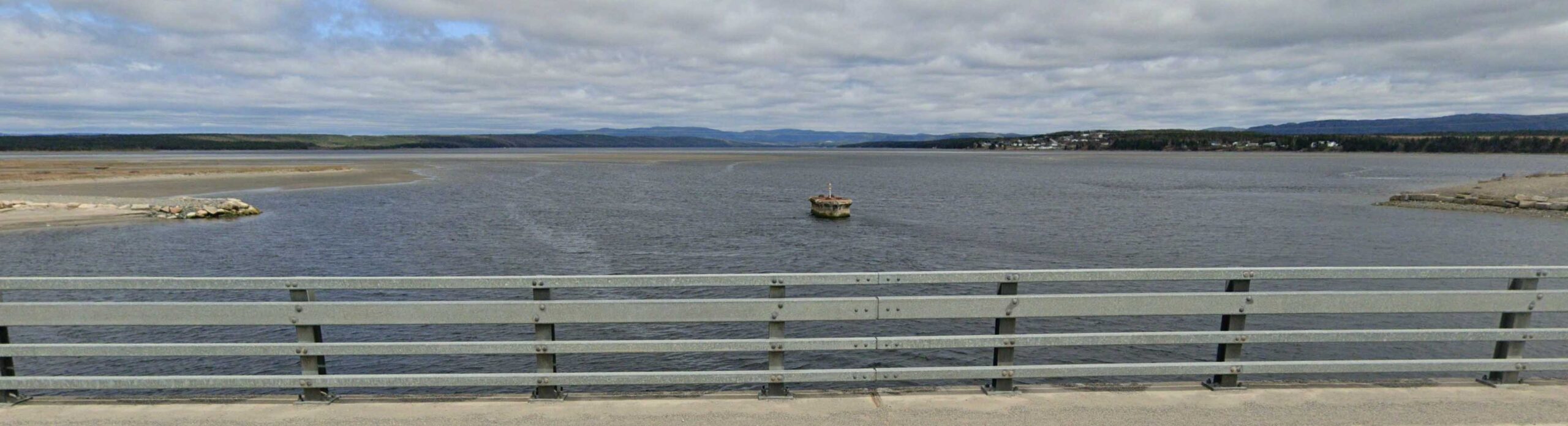
In June of 1941, construction began on a new bridge to replace the original “Gut Bridge“.

The new “Gut Bridge” on the right, was completed in the spring of 1943. To the left is what remains of the original bridge which has yet to be removed.


SOURCE: Western Star, September 5, 1943

The new steel bridge remained in service until the 1980’s, when a new highway bridge was constructed a short distance downstream. The late 1980’s also saw the end of railway operations in Newfoundland. The new bridge included a lane for motor vehicles. The lane was one-way and motor vehicles had to wait until the lane was clear before entering.

Although no longer used, the bridge still stands and is a significant icon of a gone by era.
In 2023, the government of Newfoundland and Labrador has decided, for safety reasons, to dismantle and remove the bridge.
The dismantling and removal of the Gut Bridge began in late January, 2024. The railway “Gut Bridge” has been the indisputable icon of Stephenville Crossing for more than 100 years. Soon, it will be a memory.

The "Little River" Bridge
As a child growing up in the Crossing, I heard many stories about “Little River”. Older members of my family spoke often of Little River. As a boy, I had ventured up Little River many times to camp out and do some trouting. The inflow and outflow of the 1st and 2nd ponds had good trouting.
A causway connecting Main Gut to Mattis Point was completed in 1959. Prior to the completion of this causeway, the people of Mattis Point would have a challenging 3.5 mile hike to visit Stephenville Crossing. The other option was a dory.

The 1st leg of the hike would be along the shoreline or across the marsh, before crossing “Little River” to the railway tracks. The 2nd leg would follow the railway tracks to the gut bridge and on into the Crossing.
The mouth of Little River is approximately 150 feet wide.


“A meeting was held at Nardini’s platform Friday, for the selecting of a convenient (location) to erect a bridge from Mattis Point to Nardini’s”.

Before the construction of the causeway in 1959, Mattis Point was a remote community, only accessable by small boat.
In 2024, after being exposed to the elements for more tha 80 years, the iconic Gut bridge is no longer. The bridge was removed in the interest of public safety.
References Include;
1988 ANGER – Anger, Dorothy, 1954 – , NOGWA’MKISK (Where the sand blows…) (Bay St. George Regional Indian Band Council)
http://www.heritage.nf.ca/
http://collections.ic.gc.ca/red_island/english/02history/02history03.htm
1948 BROSNAN – Very Rev. Michael Brosnan, 1894-1943, Pioneer History of St. George’s Diocese Newfoundland (Toronto Mission Press, 1948)
Newfoundland and Labrador Place Names, David E. Scott, 2012 (A DESPUB Publication)
Jukes List of Inhabitants of the Western Shore – J. B. Jukes 1839-40
Thomas, Gerald. “French Family Names of Newfoundland and Labrador” Harry Cuff Publications Limited St. John’s 1999.
List of Destitute Families of St. George’s Bay – H. H. Forrest, 28 Oct 1858
Bay St. George District Census Records
Sandy Point Immaculate Conception Roman Catholic Church
Six Months of a Newfoundland Missionary’s Journal
from February to August, 1835.
by Archdeacon Edward Wix [1802-1866], Second edition, London: Smith, Elder and Co., 1836.