The Art and Science of Finding Your Way
It is reasonable to assume that the first navigational activities began on land. It is also reasonable to assume that, when humans ventured out onto the water, the knowledge learned on land was applied on the water. Generally, that knowledge was based on our basic senses, the senses of seeing, smelling and hearing. The most significant of these would be seeing, which is exemplified by the term “Landmark”. Familiarity with your surroundings will always assist you in finding your way.
As humankind evolved and gained a better understanding of their surroundings, they ventured further and further away from their familiar “backyard”. The need to find one’s way became more important as the distance from home increased. The art and science of safely finding your way would only become more sophisticated with time.
A Very Brief History of Marine Navigation
In the very beginning……..
The first bits of navigational knowledge were gathered through observation and passed on by word of mouth.
When humans first ventured out on the water, it was very likely that his only available navigational tool was the sight of a familiar piece of land. Losing sight of that familiar “landmark” meant immediate disorientation, which meant you were “lost”.
It was likely very early in human history, when we realized that the sun rises in the east and sets in the west. It would be sometime later when, through persistent observation, we would identify the summer solstice, the fall equinox, the winter solstice and the spring equinox.
Another discovery came when a stargazer living in the northern hemisphere noticed that, there was a star that did not appear to be moving, while all other stars in the heavens were constantly in motion. Familiarity with the night sky allowed the keen observer to identify the “pole star” or the “north star”. The “north star”, also known as Polaris, appears to be more or less permanently sitting over the north pole and when visible provides the navigator with a directional reference. Not only does the “north star” indicate direction, but it’s elevation above the horizon would indicate whether or not your direction of travel has a north/south component.
Following the discovery of loadstone (magnetite) thousands of years ago, someone observed that, for a given location, the magnet had a tendency to align itself on the same axis for that location. It is no coincidence that this alignment represented the rotational axis of the earth. This alignment would eventually be referred to as north and south. Before long, a navigator would develop the first rudimentary compass. Knowledge of your direction is the most fundamental piece of information used in navigation. The mariner now knows that sun rises in the East and sets in the West. He also has a compass that aligns North and South. A universal navigational vocabulary is evolving.
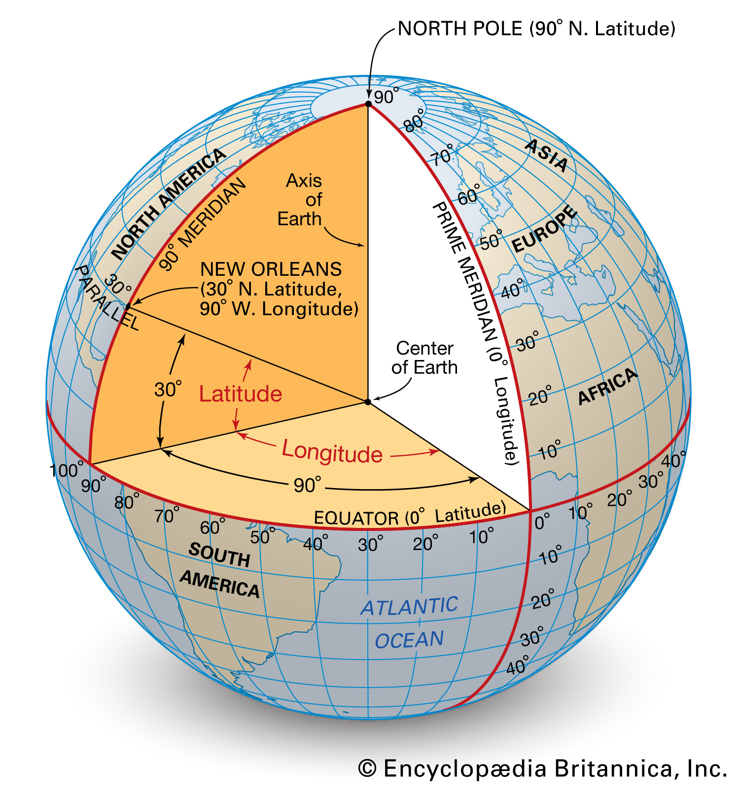
Finding your Position on the Earth’s surface
In two-dimensional space (assuming the surface of the earth to be two-dimensional), two coordinates are required to define or describe a position. In other words, a grid system. The grid system used on planet earth is referred to as Latitude and Longitude. If you know your Latitude and Longitude, then you know where you are on the earth’s surface.
Latitude is the North-South component of your position, while the Longitude is the East-West component of your position. Latitude is measured in degrees (the angle) from the equator to the poles. In the above diagram, New Orleans is located 30 degrees from the equator. So, how far might that be? Each degree of latitude equals 60 minutes and each minute of latitude equals one nautical mile. There are 60 nautical miles in a degree, so New Orleans is located 1800 nautical miles (60 X 30) north of the equator or at “300 N Latitude”.
Following these discoveries, one piece of information remained illusive until the eighteenth century. The compass enabled navigators to determine direction of travel, while the measured elevation of heavenly bodies above the horizon would indicate the north-south component of your travel. Determining the east-west component of your travel remained a challenge. Although the relationship between time and longitude was well understood, an accurate timepiece durable enough to withstand the rigors of long ocean voyages had yet to be developed.
By the middle of the eighteenth century, John Harrison’s pocket watch proves to be both accurate and durable enough to determine longitude at sea.
Conning is one those English words that has more than one meaning. The word is most often used to describe a process of deception by persuasion.
Although somewhat less familiar, the word conning is also used to describe the steering of a ship or vessel. More precisely, it describes the steering of vessel using visual aids, e.g. “landmarks”. Man’s ability to con his way, whether on land or on the water, depended for the most part on his knowledge of the area. Conning is used in confined waters, e.g. harbours, restricted channels.
If you are unfamiliar with the area, your ability to con or navigate is limited to avoiding collision with the most obvious; like the coastline, islands and rocks awash.
An important component of conning is a knowledge of the area (sometimes called “local knowledge”). This knowledge of the area would include a knowledge of what is not visually obvious, like water depth and currents. In the early days of navigation, this knowledge was gained empirically and passed on by word of mouth.
Although conning, as a navigational tool is not new, the method remains an important part of navigating in confined areas, like harbours, rivers, narrow channels and near shore.
The shoals in this picture are easily identifiable from space, but require “local knowledge” when at the helm. The channel is marked in “yellow” and can be navigated using landmarks.
When we think of piloting, we have a tendency to think of airplanes. In the nautical world, piloting is the process of steering a boat safely in confined waters, such as harbours and narrow channels, using all available information such as landmarks, aids to navigation, soundings, tidal information, speed, dead reckoning information, Radar, GPS and AIS.
Piloting by profiles refers to process by which a mariner cons his/her way safely through dangerous waters. By using landmarks as “leading marks”, the skipper can avoid known underwater dangers. This is done by identifying ranges. A range refers to the alignment of two or more natural features, such as hills. Based on a knowledge of the area, you can sometimes avoid underwater dangers, like a reef, by aligning your course with the alignment of two or more natural features.
Most commercial ports in Canada employ harbour pilots. These pilots are experienced and qualified ship’s captains, with a sound knowledge of the port for which they are employed. When foreign vessels arrive at these ports, the harbour pilot is ferried to the vessel, at which point, the harbour pilot is responsible for piloting the vessel into the harbour. Upon departure, the harbour pilot will again pilot the vessel out of the harbour.
Good conning skills and the careful application of all available information should result in good piloting skills and the safe navigation of dangerous waters.
Before electronics, navigation at sea involved the careful observation of celestial bodies. Besides calculating your position on the planet, the mariner would also need to know the location of the land masses and other navigational hazards such as shallow water, reefs, rocks, etc..
The vast majority of the hazards to navigation are in the shallow in coastal areas. The information collected by hydrographic surveys is used to draw a nautical chart.
T – True direction in degrees (from chart)
V – Variation (difference between True and Magnetic in degrees)
M – Magnetic direction in degrees
D – Deviation (difference between Magnetic and compass in degrees)
C – Compass direction (from ship’s compass)
Fill in what you know and calculate the rest. When calculating from True to Compass, west is best (positive) and east is least (negative). When calculating from Compass to True the opposite procedure is used.
The speed of your vessel is measured as the “Speed Throught the Water” (STW) and as the “Speed Over Ground” (SOG).
“Speed Throught the Water” is self explanatory and is commonly measured by a “ships log”, also called a log, a chip log and sometimes called a pitometer log. The reference to a “log” goes back to a time when a log on a knotted line was floated off the stern. Today, a “Speed through the Water Sensor” is used to collect this information.
“Speed over ground” is the speed of the vessel relative to the surface of the earth and it is typically calculated by a GPS receiver.